From Drovers’ Track to Walking Path
A drovers’ track can explain a walking path’s broad curves and old choices, helping you read the landscape instead of mistaking every bend for a detour.
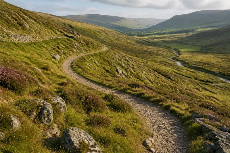
The common mistake on a drovers’ track is to treat its broad curve as a needless detour and look for a straighter line. That can cost you the best clue to the route’s past: a path shaped to move livestock across upland ground, not simply to get one walker from one point to another. Read the curve as evidence of an older journey, and a walk becomes a way to notice what the land made possible.
What the curve remembers
A drovers’ track carried animals between grazing, markets, farms, or seasonal pasture. Its route had to work for a moving group. A gradual line across a slope could be easier for animals than a direct climb; a broad sweep might avoid a boggy hollow, a broken crag, or a steep step in the ground. Where a route crossed a ridge or stream, the crossing point mattered more than geometric directness.
Those practical choices can outlast the work that created them. A track may become a public footpath, a farm lane, a bridleway, or a faint green line through heather. The surface changes, but the route may still show its older purpose in a long traverse, a roomy turn, or a steady approach to a pass.
One curve alone proves little. Modern paths also bend around fences, erosion, property boundaries, and fragile ground. Look for a sequence of clues: a broad line that keeps a comfortable gradient, a likely crossing, and a connection between old settlements or grazing areas. Maps can help, but the landscape itself often supplies the first questions.
Three ways to read it
Choose an approach to match your walk. You can follow the route as a line on the ground, compare it with the contours, or use old mapping to ask how the line may have changed. Each offers a different kind of attention.
Follow the visible line
This suits walkers who want to keep the interpretation close to what they can see. Notice whether the path widens on easier ground, narrows through rough vegetation, or sweeps around a slope rather than cutting straight up it. Look for continuity: a faint track that resumes beyond a patch of grass may be more revealing than a single obvious section.
Keep the observation modest. A worn line can reflect recent farm use or regular recreation as readily as livestock movement. The useful question is not “Is this certainly a drovers’ track?” but “What does this route suggest its users needed?”
Read the contours
This suits walkers who enjoy relating a map to the shape underfoot. Contour lines show where a direct route would become steep and where a sideways traverse might keep the climb gentler. Compare the path’s curve with the slope: does it seem to hold a fairly even angle, or turn toward a saddle where crossing the ridge would be easier?
Contours simplify real ground. A map may not capture soft peat, loose stones, a spring, or a small cliff. Use the lines as prompts, then check the view and the path from a safe position rather than treating a map pattern as an instruction to leave the marked route.
Compare older maps
This suits anyone curious about how a path’s role changed. An old map may show a track where a current map shows a footpath, or reveal that a route once linked places now connected by road. Compare the alignment, names, and junctions rather than assuming every mapped line carried livestock. Map conventions differ, and some paths were never recorded clearly.
For a short walk, this approach can be more effort than it earns. There is little point in chasing an uncertain historical label when the visible route already gives you a satisfying landscape question. Save map comparison for a route whose pattern genuinely puzzles you.
Choosing your approach
Start with what you want from the walk. If you prefer direct observation, follow the visible line and describe its shape without assigning it a firm history. If you like understanding slopes, use contours to consider why a route might curve. If you want to explore change over time, compare maps before setting out and look for the features that remain.
Imagine you reach a broad path that traverses a hillside before turning toward a low saddle. You notice that the direct line would cross a steeper bank, while the saddle offers a gentler passage. On the map, an older track follows much the same sweep. That combination gives you a plausible reading: the line may have served animals and people seeking a manageable crossing. It does not establish exactly who used it, but it turns a bend into a question you can test against the ground.
For all three approaches, use a current map and stay on the route you are entitled to use. A historical track may cross private land or have become overgrown; its presence on an old map is not permission to walk it. Where access status or route markings are unclear, check local guidance before setting out.
What bends can tell you?
Why did drovers’ tracks curve?
A curve could ease a climb, avoid wet or broken ground, or lead toward a usable crossing. The reason varies from place to place, so read the shape alongside the slope and nearby terrain.
How can I tell an old track from a newer path?
Look for a route whose broad alignment makes sense across the landscape, then compare it with mapping if you are curious. Width or wear by itself cannot establish the path’s age or former use.
Does an old map mean I can walk the route?
No. A map records a line, not necessarily a right of access today. Check current local access information and follow signs and marked paths.
What should I notice on the walk?
Notice where the route holds a steady traverse, where it turns toward a pass, and what obstacles it avoids. Those details help you form a grounded interpretation without needing to settle the path’s full history.
Let the line lead
The most useful way to read a former drovers’ track is to combine curiosity with restraint: follow its curve, consider the terrain, and let maps add context rather than certainty. A walking path may preserve the logic of moving animals even when its old purpose has faded. Next time a route seems to wander, pause at the bend and ask what kind of journey it made easier.